Preserving the past and heritage of this wonderful village at the heart of the New Forest
Domesday Book
The Domesday Book was an audit and record of Britain after the Norman invasion of 1066. It was started by William the Conqueror, who died in 1087 a year after its completion. Much of the work it is believed was carried out by crown agents on behalf his son William II (William Rufus).
It is likely they took particular interest in the New Forest which had been proclaimed a royal forest in about 1079 by William the Conqueror. It was used for royal hunts, mainly of deer. The forest lands were created at the expense of more than 20 small hamlets and isolated farmsteads; hence it was then 'new' as a single compact area. The land was taken over by the Crown, who cleared many farms, homes and fences to create a forest. Only a few private holdings remained, and it is assumed that those landowners, such as Aluric (below) were on friendly terms with the monarch.
The New Forest was first recorded as 'Nova Foresta' in the Domesday Book, and it is the only forest that the book describes in detail.
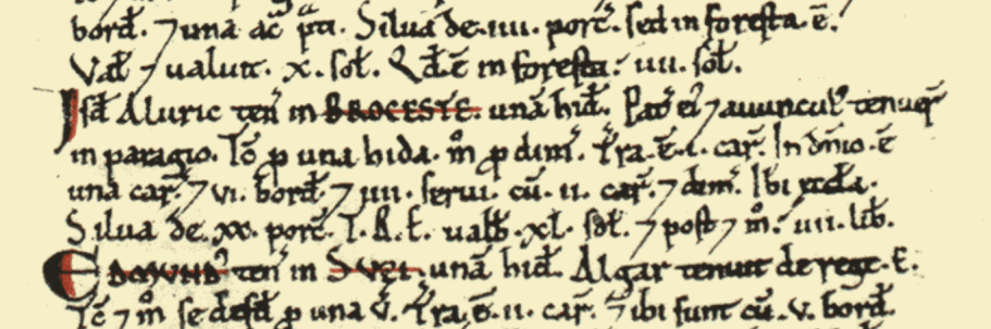
The Domesday Book, which was completed around 1086. It is the first relatively complete record of England and was written in Latin. Its prime purpose was to record the property of the King and thus regulate rental income. Brockenhurst as we know it today, is essentially recorded in three manorial records – Broceste, Brookelie, and Hinchealea with Mapleham.
Broceste (essentially the land south of the modern rail line including St Nicholas Church and Brockenhurst Park and east of Lyndhurst Road). It is Broceste (which meant a wooded area) which likely gives the modern village its name.
Broceste, then in the parish of Boldre, is recorded as being in the ownership of Aluric (the small), Lord of the Manor, and consisting of 10 households. This make it among the smaller settlements recorded. Six households are smallholders ('bordars') who rented their land, and thus farming for themselves. The remaining four are described as slaves ('serfs') of Aluric and thus working for him. In all likelihood these were servants rather than slaves in the sense of ownership.
The land consisted of one ‘ploughland’, an area for growing crops, one lord's (Aluric’s) plough teams and two and a half other men's plough teams, belonging to the small holders. There was also woodland, sufficient to sustain 20 swine (pigs, described as 'silva de xx porc') and one church. This is St Nicholas Church, and as such the only one in the new Forest which is recorded in 1086.
A ploughland (also known as a 'hide') was a fiscal unit representing the amount of land an eight-oxen plough team could till in a year, nominally around 50 hectares (120 acres), but its actual size varied greatly by location and soil quality, acting more as a tax assessment base than a fixed measurement. Another possibility is that a ploughland/hide was the amount of land sufficient to feed a family for a year. This would explain why, for example, it varied in relation to the quality of the soil for growing.
Annual value to Lord, rent paid by small holders was four pounds in 1086; doubling from 1066 when it was two pounds.There is no explanation, but it’s clear Aluric had won favour with the monarch, not only allowed to keep his land as the New Forest was created, but also allowed (possibly) to earn more from his holding. Aluric also held land, which had been passded down through his family in Pilley; Milford (Milleford); Efford (Einforde) and Miteful (the location has not been identified).
Brookelie (approximately the modern village lands stretching to Latchmoor)
Brookelie belonged to King William II himself (as much of the then genuinely New Forest with land seized from owners; continuing to this day as ‘Crown Lands’). This consisted of seven ploughlands, and paid rent of one pound a year to the King. The farming tenant was called Ednod.
No households are recorded, but it seems likely that the smallholders and farmers would have lived here. It gives its name to the modern Brookley Road, the village high street.
Hinchealea/Mapleham (property to the north and north west of Brockenhurst including the modern Hincheslea area)
Like Brookelie, Hincheslea is described as belonging to King William, as crown land for hunting primarily and tenanted by Wislac. It consisted of two ploughlands, and paid rent of one pound a year to the King.
While the name Hincheslea and thus its location can be traced today, the location of Mapleham manor has not been identified in modern times, but it is possibly the area stretching from Wilverley across to Whitemoor. Mapleham is recorded as having no residents and this suggests it had already been abandoned as a settlement.
It is recorded that William Rufus was killed by an accident arrow while hunting in the New Forest in August 1100. However some believe he was murdered as revenge for the clearance of farms and homes a few years previously to create the forest.